Departure:
Chiavenna
Arrival:
Verceia
Distance:
25 Km
You walk along the “Via Francisca” (various signs/indications in yellow: metallic “Historical path of the valley” or “Via Francisca” or “yellow paint stamps”), and then you cross the cycle-pedestrian path “Val Chiavenna cycle path” (sign brown) A possible variant can be represented by the “Val Chiavenna Cycle Path” starting from Chiavenna.
In Chiavenna, you start from Via Marconi (where there is the SS36 roundabout), then continue along Via Volta, and after the bridge over the Liro stream, you continue along Via Trivulzia (in the Municipality of Mese). Continue along Via Trivulzia, which then, in the Municipality of Gordona, becomes Via Mondadizza and finally Via Crezza. At the end of Via Crezza, you come across a roundabout where you cross Via Scogli. After a few meters, you come across Piazza San Martino, where the Municipality of Gordona is located. In the car park in front of the Municipality, turn left onto Via Piazzoli (where there is a clearly visible “yellow mark”). Continue along the street, and further on, you will come across a sign indicating “Via Francisca.” Continue following the signs and yellow “stamps” along the “low variant” (signposted to the left immediately after crossing the bridge over the Boggia stream): an hour less walking along the Mera river and passing before San Pietro, the hamlet of Samolaco, for the Oratory of Sant’Orsola alla Cesura. At the hamlet of San Pietro at the end of via Overina, turn left into via Tonaia. Follow Via Tonaia to go towards the bridge over the Mera. Immediately after crossing the bridge, take the “Val Chiavenna cycle path” on the right again (cycle-pedestrian itinerary), indicated with brown signs. Go along the Mera along the cycle-pedestrian path (of Valchiavenna). Once again, you come across a bridge over the Mera. Here, the cycle path passes under the bridge and continues in the countryside that runs along the river up to the hamlet of Giumellasco. The street takes this name and shortly after becomes Via Giumello.
From the hamlet of Giumellasco, the road is also passable by cars: be careful! We are now at the gates of Novate Mezzola, where we take the bridge at the end of Via Giumello pedestrian on the Mera. At the end of the bridge, turn right and take the Valchiavenna cycle-pedestrian path (via al Lido), which takes you along Lake Novate Mezzola to the town of the same name. Here, in the Campo hamlet, the Oratory of San Colombano is worth a visit, an ancient parish building built on the remains of the ancient monastery founded by the monks of Bobbio (from via Lungo lago, take Rue Saint Colomban until you reach the Oratory). The stage ends in Verceia at the Church of San Fedele (a few steps from the lakeside).
B&B Il Sorriso
Loc. San Pietro
Via Peremonte, 22°
tel.: 340 5790090
apertura annuale
Agriturismo Summus Lacus
Via Siberia, 5
tel.: 333 1087966
apertura annuale
La Casa dei miei nonni
Via XXI Aprile, 16
2-4 posti, DBL 70-90 €, uso cucina e lavanderia, caffè, tè, posto bici con ricarica batteria.
tel.: 3332427751
mail: oregioni.mara@gmail.com
Facebook
Hotel Saligari
Via Copes 29
SGL 70-80 €, DBL 100-110 €
tel. 0343-39.100
e-mail.: info@hotelsaligari.com
www.hotelsaligari.com


Previous
Next


Previous
Next
Bar Val di Ratt
Via Nazionale, 60
open every day from 6 am to 11,30 pm
Chiosco Verde
Via Walter Corti, 145
Only in summer
Two routes lead to the lesser-known treasures of Mese, to be admired on a beautiful walk. Well-signposted and accessible on foot, they offer a different approach to the resources of the municipality to observe unknown views, somewhat hidden frescoes, and historic buildings.
The Via della Val Grande
We start from the large hydroelectric power plant, built in the town in 1927 and inaugurated by Prince Umberto of Savoy. The building is now an integral part of Mese’s urban planning.
Its construction was celebrated by the press of the time. Even today, this is the largest plant in the province. Not far away, the church of San Vittore, whose first written traces date back to 1100, recalls the devotion towards the Roman soldier who came martyred in Milan in the 3rd century. The Stampa building is another example of a farmhouse in Mese. Note the beautiful clock face with a diameter of one meter, which stands out on the facade.
The Via dei Crotti and Böc.
You walk from Fontanin to Crotti di Scandolera. The route offers various views of the town, telling the story of the most representative corners.
Like the fresco of the Blessed Virgin of Health, dating back to 1871, which is still clearly visible today on the facade of Casa Dell’Acqua at 65 via Scandolera. A devotion that was brought to Mese by the emigrants to Venice once they returned to the valley. The “casin”, however, was the home of the curate. The decorations still visible on the facade suggest that the building dates back to the early 1800s. Not far away is the delightful baroque portal that decorates the entrance door of what was the house of the Notary Prevostini (1798). Mese celebrated the tradition of the Milk Cooperative, founded by Don Primo Lucchinetti, with a museum that tells the story of its production. Mese, like many other towns in the valley, has a lot to tell. Take the time to do it. It’s worth it.
The name perhaps derives from “cortona”, i.e., “large court,” or from the pre-latin root “ghordt”, i.e. “enclosed place”. More poetic is the hypothesis that it derives from “cor dona,” that is, “give your heart,” signifying the generosity of the inhabitants. It is located on the right side of the Chiavenna plain, at an average altitude of 283m above sea level. The municipal territory, which develops along the border with Switzerland, is characterized by notable variations in altitude, consisting of a panorama particularly rich in streams and waterways. The inhabited center is surrounded by cultivated fields and vineyards and is affected by a phenomenon of building expansion that is widening its boundaries.
What there is to see in Gordona:
Church of San Martino
Church of Santa Caterina
Torre di Segname
There is a beautiful itinerary from Gordona to Alpe Cermine. And then, even further up to Alpe Cima (or Scima) and Alpe Forcola with the bivouac, which are open all year round. Discovering these splendid mountain villages. But also Fughiascia, the traditional focaccia from Gordona.
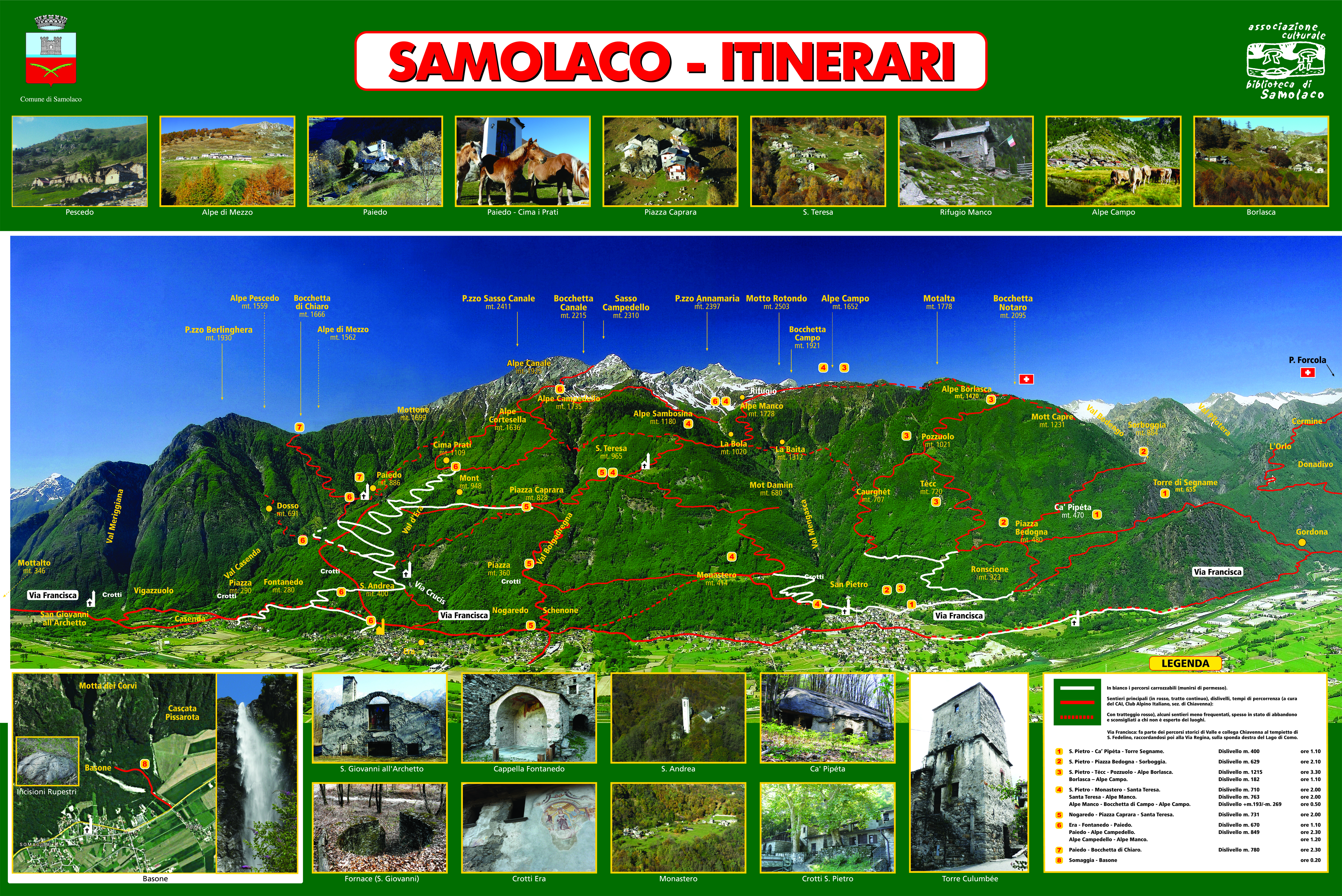
Samolaco owes its name to the geographical location at the northern end of Lake Como. In the past, the village must have been built near the ruins of the church of Saint John all’Archetto, where the remains of lime kilns are still visible today. The Via Francisca, the continuation of the Via Regina, also passed through there. Thanks to these routes, we reached Chiavenna and proceeded through the passes beyond the Alpine chain.
What to see in Samolaco.
Now, walking along the historical paths, you come across testimonies of the past preserved in the old buildings, in the ruins of San Giovanni all ́Archetto, in the church of S.Andrea al Colle, in the Culumbée Tower or in the Cà Pipéta.
If you take short detours, you reach Monastero, Stalla, Fontanedo, Ronco, and Paiedo. In addition to those already mentioned, there are still many ancient centers to be valorized: the old part of Era (Cuéta), Casenda, Vigazzuolo, and the remains of the abandoned farmhouses halfway up the hill (Cusciago, Piazza, Macolino, Piazza Bedogna).
VIA FRANCISCA
The historic route constitutes the continuation of the ancient Via Regina (from Como to the upper Lario, right bank) and reaches Chiavenna, keeping to the right side of the Valley.
From the Tempietto di S. Fedelino, you go up along the course of the Mera river until you reach the large fan of the Meriggiana and Casenda streams, which, with their floods, decreed the end of the ancient nucleus. The path continues up to Vigazzuolo. After crossing the Casenda stream, you reach the village of the same name and climb up to the moraine terraces.
Continue towards Luoghi, Sassello, Schenone, and Prona to reach the church of S. Pietro, just beyond the medieval Culumbée tower. From here, you follow a path that goes down to the Riverina crossroads and continue up to the Cesura plain.
Take a comfortable and wide path and cross the bridge that crosses the final course of the Boggia stream. You pass Gordona and continue beyond Mese, concluding the route at the Postaiolo bridge, at the entrance to the Spluga Valley.
An enormous esplanade between Lake Como, Val Chiavenna, and Valtellina to immerse yourself in nature and observe it in all its beauty. Reachable by car but also by train, the Pian di Spagna Nature Reserve is a truly suggestive destination if you love walking or riding a cycle touring bike. It extends over an area of approximately 1500 hectares, at an altitude of 200 meters, between Lake Como, Val Chiavenna, and Valtellina; it is a protected area belonging to the European Ecological Network “Natura 2000”; this means that this Reserve stands out, as we will see, for the presence of a great variety of animal and plant species, as well as habitats and ecosystems to be safeguarded.
This enormous esplanade between Lake Como, Val Chiavenna, and Valtellina was once an expanse of water: in Roman times, in fact, Lake Como and Lake Mezzola were united. As time passed, however, the debris transported by the Adda River due to frequent floods formed the current Pian di Spagna. And when, following a reclamation operation, the canalization of the Adda basin was revised, the hydrogeological situation could be considered resolved.
One of the strengths of this Reserve is its complex ecosystem, which features reed beds, marshy areas, meadows, and still cultivated areas. Not to mention the landscape aspect: just consider that in its extension, there are three different mountain chains (Mount Berlinghera in the Lepontine Alps to the north-west, the Rhaetian Alps which embrace the Valle dei Ratti and Val Codera to the north-east, Mount Legnone to the south) and three different lakes: Lake Dascio, part of Lake Como and Lake Mezzola.
What you can see in this Reserve will definitely exceed your expectations. As regards the flora, the marsh reeds (Phragmites australis) are accompanied by the common cattail (Typha latifolia), water lilies (Nymphaea alba), and maneuvers (Nuphar lutea). In the most humid areas, everything is surrounded by willow, alder, and poplar woods.
Freshwater fish such as pike, perch, trout, and eels abound in the waters of the numerous canals. Frogs and toads populate the ponds, while among the mammals, there is no shortage of various undergrowth animals, as well as foxes, hares, and a small population of deer.
Suppose you would like to dedicate some of your time to bird watching. In Reserve, there is a multitude of birds: over 24 species of aquatic birds and another 200 different species of migrated birds.
With at least five days’ notice, it is possible to organize excursions in the Pian di Spagna Nature Reserve. Among the main routes and practicable paths, there is the one that leaves from Dascio to reach the Tempietto of San Fedelino in Sorico, accessible to all and lasting approximately 3 hours; a circular route with arrival and departure from the town of Beletrone, which winds inside the Reserve; the one that from Ponte del Passo to Sasso di Dascio allows you to observe a large number of aquatic birds and that allows you to enjoy a panorama of Lake Mezzola: the one that from Trivio di Fuentes, near the Ponte sull’Adda, allows you to arrive also by bicycle to Cascina Lodoletta, and which gives you the opportunity to see the Fuentes fort.
Bathed by the waters of Lake Mezzola, one of the bathing lakes of Lombardy, north of the better-known Lake Como, Novate Mezzola opens up to the docile Lombard countryside, maintaining this bucolic approach since the Lombard era, when it was under control vigilant and authoritarian of the Abbey of San Colombano. Thus, it spent a good part of its Middle Ages, dominated by episcopal and parish orders, until modernity shook the administrative status quo, very slowly but effectively advocating a municipal unification including Novate, Verceia, Vico, Scellio and Lezzeno Superiore, in short, a merger of five cantons which in any case maintained their own economies and related management. With the formation of the Cisalpine Republic, Novate Mezzola had now become a municipal reality subject to District III of Sondrio. During the various processes of administrative evolution, Novate experienced a fair population, yet today, we cannot speak of a city or town but of a town with not even 2,000 inhabitants.
What to see in Novate Mezzola
Its historic center is very liveable today, in which the elegant mass of the Parish Church of the Holy Trinity stands out, the foundation of which cannot yet be attributed to a specific date. The Parish Church of San Colombano a Campo, on the other hand, has a date of birth of 1955. Many other ecclesiastical buildings stand in the area, including the Church of Sant’Antonio Abate di Campo, the Church of Cristo Re near Bresciadega, and the Church of Saint Fedele at Saint Fedelino. The beach of Lake Mezzola is a restricted, intimate, and small heritage and invites a short visit, unlike a hinterland which must be explored with great care passing through Lake Mezzola, which is not only an avifaunal oasis but also an attraction for those who love swimming in more than calm waters and relaxing on the shore of an equipped beach. Hikers can dedicate themselves to exciting nature trails such as the Sentiero Roma and the Sentiero Italia, which wind through the most beautiful Alpine ridges. The lakeside, it must be said, also includes a suggestive and easy-to-follow cycle path, without particular differences in level and immersed in the lakeside nature.
A country rich in history, scenic beauty from the lake to the mountains, itineraries, traditional flavors, events and re-enactments, sports, and much more.
The first center of Valchiavenna for those coming from the south, Verceia overlooks Lake Mezzola, which makes this unique habitat suggestive, as well as offering the possibility of rowing, bathing, and docking small boats.
One of the most scenic cycle paths winds along the shores of the lake and enters, for a stretch, the Pian di Spagna Oasis: a protected nature reserve, a fundamental stop for migratory fauna.
EXCURSIONS
From Verceia, you can access the Valle dei Ratti. Here, there are two main locations once upon a time always inhabited: Frasnedo at an altitude of 1287 m. with the small church dedicated to the Madonna della Neve from 1677 and with a bell tower from 1844, and Foppaccia with a small church built in 1762 in honor of Sant ́Anna.
Much sought after by both hikers and mountain bike enthusiasts is Tracciolino a route characterized by tunnels dug into the rock and a “decauville”, the historic track for the transport of goods. The route was opened in the 1930s as a service infrastructure for the transport of goods and as a connection between two dams, one in Val Codera and the other in Valle dei Ratti.
The overall length of the Tracciolino path is approximately 14 km, but at the moment, only 8 have been made safe and can also be traveled by mountain bikes. Map download


